Geocoding & Location API
Project Overview
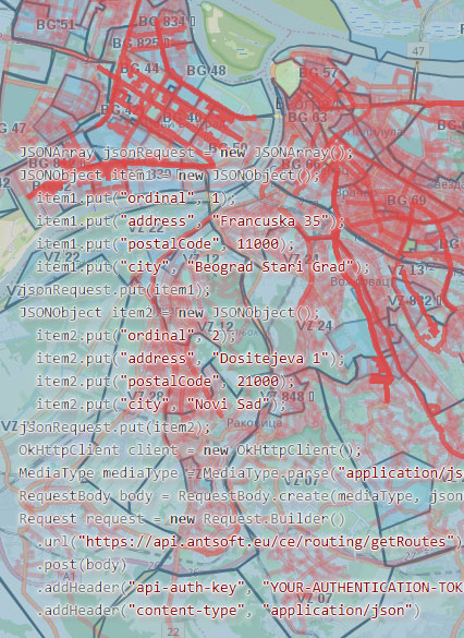
The REST Geocoding & Location API is a geospatial web service designed to help delivery systems efficiently match user addresses with nearby parcel shop locations and determine
optimal delivery routes. It is powered by a custom spatial database built on OpenStreetMap (OSM) data and enriched with proprietary delivery zones, custom polygons, and routing lines.
This API is actively used in production by one of the leading parcel delivery companies in Serbia, City
Express, and currently handles nearly 1 million requests per month - delivering high availability, performance, and reliability at scale.
Its modular architecture allows for seamless integration into various platforms via standard RESTful interfaces.
Key Features
-
Address GeocodingParses and geocodes structured and unstructured addresses in real time.
-
Parcel Shop LocatorFinds the nearest pickup/drop-off points based on geographic coordinates i.e. addresses.
-
Route DiscoveryReturns the most efficient parcel delivery route from a given origin.
-
Spatial Data EnginePowered by a custom spatial database built on OpenStreetMap data, enhanced with proprietary spatial data such as polygons and routing lines.
-
Secure AccessAll API endpoints are protected via HTTPS and require an API key for authentication and rate limiting.
-
Fast & ScalableBuilt using modern REST principles, suitable for integration with mobile apps, logistics systems, or e-commerce checkouts.
Use Cases
- Integration into e-commerce checkout systems for dynamic parcel shop selection.
- Internal tools for courier and logistics companies to plan pickup/delivery routes.
- Mobile apps allowing users to locate nearby service points based on current GPS location.
Tech Stack
- Frontend: JSON
- Backend: Java, Spring Boot, PostgreSQL + PostGIS
- Platform: Web-based (runs on intranet or Internet)
- OS Support: Fully cross-platform (Windows, Linux, macOS)
Challenges & Solutions
- 🧭 Challenge: Matching imprecise or partial addresses to actual geolocations.
✅ Solution: Implemented fuzzy geocoding with ranking and fallback strategies. - 🗺️ Challenge: Combining public OSM data with proprietary logistics zones.
✅ Solution: Built a layered spatial model with region-based filtering and indexing. - ⚡ Challenge: Ensuring fast response times under concurrent load.
✅ Solution: Applied PostGIS indexing strategies and route caching for high-demand areas.
My Role
I was fully responsible for system architecture, spatial database design, REST interface definition, code implementation, performance tuning, and maintenance. I also led integration support with client systems.